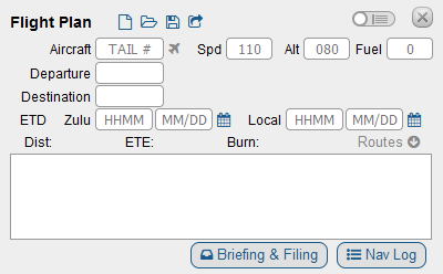
Place the cursor in the white box to begin typing.
Waypoints
Airport
Enter ICAO code
Examples: 06C, KMKE
VOR/NDB Station
Enter the ICAO code
Examples: OBK, DPA, TII
VOR/NDB Radial and Distance
AAABBBCCC
AAA is the 3-digit ICAO Code
BBB is the 3 digit radial
CCC is the 3 digit distance in nautical miles.
Enter the ICAO code immediately followed by the 3-digit radial and immediately followed by the 3-digit distance in nautical miles. Fractions of a mile and fractions of a radial are not permitted.
Examples: OBK090010, Northbrook VOR, 090 radial, 10 nm. DPA360005, Dupage VOR, 360 radial, 5nm. Alternatively DPA000005, Dupage 000 radial, 5 nm.
VFR Waypoint, Intersection, RNAV Waypoint
Enter the 5-digit code
Examples: VPFTS, Fort Sheridan. CHIKO RNAV waypoint. PAPPI intersection
GPS Coordinates
AA(BB)(CC)DEEE(FF)(GG)H
AA is the 2-digit latitude in degrees
BB (optional) is the 2-digit minutes
CC (optional) is the 2-digit seconds
D is N or S for North or South
EEE is the 3-digit degrees of longitude
FF (optional) is the 2-digit minutes of longitude
GG (optional) is the 2-digit seconds of longitude
H is W or E for West or East.
Enter the GPS coordinate all as one large block. Convert decimal minutes into seconds before entering.
Routes
Victor Routes
Victor routes should only be entered in between two waypoints, or between a departure and destination. Enter the Victor Route. SkyVector will fill in the start and end points of that route.
Example: 06C to KJVL, enter V24. SkyVector fills in OBK V24 JVL. KPWK to UMUZI to KJVL. Enter V24 after UMUZI. SkyVector fills in UMUZI V24 JVL.
Modifiers
Modifiers are added to waypoints to change either the altitude or speed at that waypoint. To add a modifier, add a forward slash / after the waypoint. Then add the type of modifier. To modify both speed and altitude include both with no spaces between, e.g. /A045N0110. Important: the cruise altitude and speed entered at the top of the flight plan should be reached at or before for the first waypoint. When altitudes are modified, SkyVector will compute TOC and TOD based on aircraft performance in the NavLog. Altitude modifiers are the altitude that will be reached, if possible, after the waypoint is reached.
Altitude in Feet
A###. The numbers are feet in hundreds.
Example: /A045 to change the altitude of the waypoint to 4500 feet MSL.
Altitude in Flight Level
F###. The numbers are the flight level.
Example: /F160 changes the flight level to FL160. /F060 changes the flight level to FL060 (6000 feet).
Airspeed in Knots
N####. The numbers are knots.
Example: /N0120 changes the airspeed to 120 knots.
Airspeed in Mach
M###. The numbers are hundreds of the Mach number
Example /M095 changes the airspeed to Mach 0.95
Departures and Arrivals
Departure Procedure
Departure procedures should only be filled in after the Departure Airport is filled in. Enter the 5-character name immediately followed by the number of the procedure. Skyvector.com will fill in the fixes based on the departure. The NavLog will have all waypoints of the departure procedure.
Examples: JORJO5, JORJO FIVE from KPWK. Skyvector will fill in JORJO. UECKR6, UECKR SIX departure from KMKE. Skyvector will fill in UECKR.
Arrival Procedure
Arrival procedures should only be filled in after the Destination Airport is filled in. First enter a waypoint listed on the procedure, then enter the 3 to 5-digit code for the procedure immediately followed by the number of the procedure. The NavLog will have all of the waypoints of the arrival procedure. Note, for arrivals with more than one route converging, only waypoints after the merge can precede the arrival; waypoints along the branches cannot be used with arrival procedures.
Examples: BDF BDF7, BRADFORD SEVEN arrival at KORD starting at waypoint BDF. GOPAC GOPAC2, GOPAC TWO arrival at KMKE starting at GOPAC.
Examples
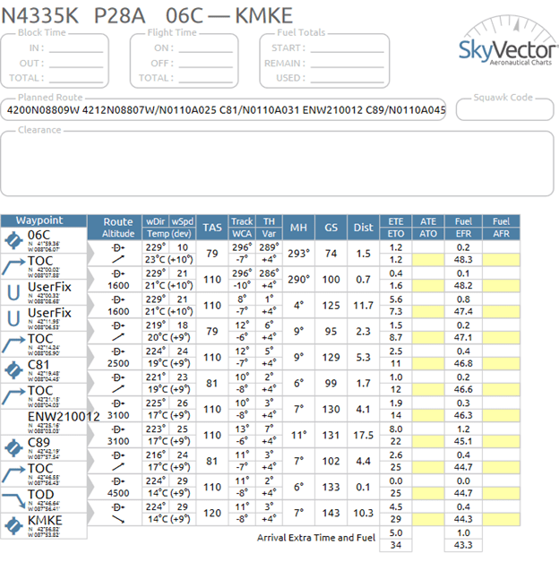
06C 420019N0880841W 421157N0880632W/A025 C81/A031 ENW210012 C89/A045 KMKE. Spd 110, Alt 016.
Start at 06C. Fly to the intersection of Barrington Rd and Irving Park Rd at 42°00’19″N, 88°8’41″W reaching an altitude of 1600 feet. Fly to the Lake Zurich reporting point at 42°11’57″N, 88°06’32″W and then climb to reach an altitude of 2500 feet at or before this waypoint. Fly over Campbell Airport C81 and then climb to reach an altitude of 3100 feet. Fly to the chain of lakes at Lindenhurst that is 12 miles on radial 210 of the ENW VOR at Kenosha. Overfly Sylvania Airport C89, then climb to reach an altitude of 4500 feet at or before this point. Fly and land at KMKE. Based on the current weather at the time of writing, the following plot and Nav Log are created.

Contrast this with the following example where the climbs were all moved up one leg.
06C 420019N0880841W/A025 421157N0880632W/A031 C81 ENW210012/A045 C89 KMKE
Start at 06C. Fly to the intersection of Barrington Rd and Irving Park Rd at 42°00’19″N, 88°8’41″W after reaching an altitude of 1600 feet. Begin a climb to 2500 ft while turning to fly to the Lake Zurich reporting point at 42°11’57″N, 88°06’32″W. Begin a climb to 3100 feet while flying towards Campbell Airport. Fly to the chain of lakes at Lindenhurst that is 12 miles on radial 210 of the ENW VOR at Kenosha, then begin a climb to 4500 feet. Overfly Sylvania Airport C89, then fly to and land at KMKE. Based on the current weather at the time of writing, the following plot and Nav Log are created.

Start a new flighit plan and try entering this into the navigation:
I69 390527N0840326W 390626N0835057W 390752N0833233W 390903N0831303W KEOP/N0095 392030N0825556W XUB110002 LCK V19 I23/N0100A041 MXQ145005 I69
SkyVector.com creates the following flight plan. Notice that in between V19 the waypoints JORUV and GAILL were added automatically.

Adding speed and alt of 110 and 050, respectively, the following NavLog is created. Note that since the V19 was used, instead of the direct-to symbol in the Route we get the V19 route.

