The homework assignment: 3-legs, around 180 nm, cross country with some hood work. I spent most of the day Saturday working out the plan. The first stop was the same location we did the last two cross countries, but the second stop is a totally new airport. However, there were a lot fewer features on the sectional chart between these two.
I feel like it takes me way too long to put together cross countries. It’s taking me hours to work all of this out. I don’t know if I am over-thinking the paper and pencil navigation log or I’m just not practiced at it yet. I hope it’s just the latter and that these sorts of things get easier with practice. The hardest part of all though is how long it takes to figure out the climbs and descents. I have to say, the chase around plot is fine for showing a lot of information, but holy hell is it hard to pick out precise numbers. Do the numbers even need to be so precise? Case in point, the fuel, time, and distance to climb chart.

If you’re climbing to a pressure altitude of 8000 ft then there’s a lot of gap in between the lines. The climb out of my home airport is under a class B shelf. The first climb is 800 feet, the next is 900 feet, the next is 1000 feet, and then another of 1000 feet to cruise altitude of 4500 feet. Dear Piper, can you maybe spread out that lower chart a little bit? Maybe a logarithmic horizontal axis instead? It actually grinds my hears a bit when there are only two squares between 5. And this is a pressure altitude, so the first climb is to maybe 500 feet pressure altitude and at a temperature of -2°C…that’s zero on the chart. I guess you could just use the climb performance chart on the previous page of the POH, but again, we’re taking off below the chart…do I just use around 770 fpm, and assume 1 minute, 9 gal/hr = 0.15 gallons of gas?
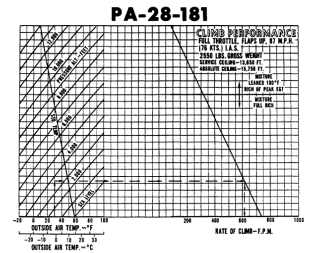
I printed off full-size pages of these charts to do my flight planning. These climbs under the class B drive me nuts. I actually really enjoy doing the one out of the towered airport because I don’t have to deal with these small climbs in my nav log. Straight up to a pressure altitude of 4000! Easy…ish! That’s like halfish way between 0 and 2.5 gallons, just under 5ish minutes, and halfish way between 5 and 7.5 nautical miles.
The descents are a little bit tricky also. 3:1 descent is the rule. 3 NM per 1000 feet of altitude. Extrapolating the math, 100 knots ground speed will take 1.8 minutes to cover 3 nm, and so to descent on time the rate needs to be 555 fpm. However, ground speed is a big variable. We could be doing anywhere from 70 to 130 knots over the ground depending on the winds. I like to assume a 500 fpm descent, but here’s the bitch of all of this – the top of descent you don’t know until you know the ground speed, and you don’t know the ground speed until an hour before the flight because you don’t know the winds. Sometimes the top of descent is before a waypoint, sometimes it’s after. Or do you just assume 3 NM per 1000 feet always and adjust the rate of descent? Everyone uses the 3:1 rule, so I generally do that. But my planning so far has not involved calculating the actual descent rate. I don’t know why nav logs don’t explicitly call this out.
While I was filling in all the angles and ground speeds the day of the flight the weather was just not being consistent. The second leg to the new airport was flipping between MVFR and VFR all day. Ultimately when I arrived it was overcast with clouds at 2100 feet. Clouds are reported in AGL, not MSL, and the airport is 650 feet, so it would be a very quick flight. I planned that leg for 5500 feet the night before… do I replan it for 2200 feet on the fly? All new top of climb and top of descent points. Ultimately we decided to just go to the first airport and back with the plan of doing hood work on the way back.
This takeoff was to the opposite direction this time. I’ve never taken off to the East before. Right away, the first climb is not enroute. Maybe it’s just the constant climbs up from the class B and calling up approach control for flight following, but right away I fell behind the airplane and did not even catch my first waypoint. I forgot to set and reset the timer, record times. I was focused on keeping the heading and listening to the controller and spotting my waypoints and changing the radios and changing the VOR receiver and shuffling papers and charts. I think what I’m missing is having a plan in my mind about what I will do and what comes next. I need to chair-fly this, and practice it on X-plane, and rehearse all of the tasks and internalize all of this.
On the way back I put on the yellow foggles and it was time for instrument work. I rocked hood work. The phrase “blue power through, brown power down” was new to me, but it makes sense. If the attitude indicator shows you pointing downward you’re accelerating and you need to power down to avoid over-speed. I guess all the years of sim flying made me predisposed to having a good instrument scan. It’s really just keeping your eyes moving and back to the attitude indicator. Start with the AI and at each other instrument one at a time. Did some standard rate turns. Another rule of thumb: airspeed / 100 + 5 is the angle of bank. 100 knots airspeed / 10 + 5 = 15° of bank.
We also did a little bit of lost procedures. The five (six) Cs: Climb (to get a better view and get better radio reception), (Circle to stay in place and figure out where you are), Confess (that you’re lost), Communicate (with anyone you can get on the radio), Comply (with whatever instructions you get), and Conserve (fuel by reducing power). Using VOR triangulation, I used Avare! and drew the approximate radials. Precision is not necessary – just get an idea of where you are using the two radials and find the landmark on the sectional that will help you navigate. Circle while this is going on so you don’t move too far from your original VOR radial while the second one is being dialed in.
I still have to learn Morse Code. I print off a radio sheet with my flight plan and this time I added the morse code for the VORs. One is supposed to identify them by listening to them. It helps to know the Morse Code. I will have to take some time to learn it so that I don’t need a cheat sheet…one more thing to distract me when I’m already task saturated that I need to eliminate or internalize.
